Biblical Geography: Northern Israel and Coastal Lebanon
by Felix Just, S.J., Ph.D.
Introduction:
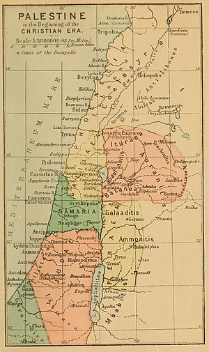
When King Herod the Great died in 4 BC, his territory was split between three of his sons and one daughter. His son Herod Philip received control of the northeastern regions, ruling until AD 34 as "Tetrarch" over the territories of Iturea, Trachonitis, Gaulanitis, Auranitis, and Batanea. He made his capital at Caesarea Philippi, just east of ancient Dan, near one of the headwaters of the Jordan River. In some periods of the Old Testament, the tribe of Dan lived in this region.
Mount Hermon (9232 ft), on the northern tip of this region, is covered with snow much of the year, and thus is the source of much of the waters in these regions. It is mentioned 16 times in the Old Testament (Deut 3:8-9; 4:48; Josh 11:3; etc.); it is not named in the New Testament, although many scholars believe it is the "high mountain" where Jesus was transfigured (see Mark 9:2; Matt 17:1).
The Gospels also mention some non-Jewish regions and cities to the northwest of Galilee, the coastal regions of the Eastern Mediterranean Sea that were settled by the ancient Phoenicians; this area is sometimes called Syrophoenicia (today's Lebanon) and includes such ancient cities as Tyre and Sidon. People from Tyre and Sidon are said to come to Jesus at various times during his public ministry, and Jesus even goes into this region at least once. The Acts of the Apostles once also mentions the coastal harbor city of Ptolemais (later called Acre or Akko).
Luke 3:1 – In the fifteenth year of the reign of Tiberius Caesar, when Pontius Pilate was governor of Judea, and Herod was tetrarch of Galilee, and his brother Philip tetrarch of the region of Ituraea and Trachonitis, and Lysanias was tetrarch of Abilene,
Mark 8:27 – Jesus went on with his disciples to the villages of Caesarea Philippi; and on the way he asked his disciples, "Who do people say that I am?"
Mark 9:2-3 – After six days Jesus took Peter, James, and John and led them up a high mountain apart by themselves. And he was transfigured before them, / and his clothes became dazzling white, such as no fuller on earth could bleach them.
Matt 16:13 – Now when Jesus came into the district of Caesarea Philippi, he asked his disciples, "Who do people say that the Son of Man is?"
Matt 17:1-2 – After six days Jesus took Peter, James, and John his brother, and led them up a high mountain by themselves. / And he was transfigured before them; his face shone like the sun and his clothes became white as light.
Note: The parallels in Luke 9:18-21 and 9:28-29 do not give a geographical location for these episodes.
The Syrophoenician coast, including Tyre, Sidon, and Ptolemais:
Matt 11:21-22 – "Woe to you, Chorazin! Woe to you, Bethsaida! For if the mighty deeds done in your midst had been done in Tyre and Sidon, they would long ago have repented in sackcloth and ashes. / But I tell you, it will be more tolerable for Tyre and Sidon on the day of judgment than for you.
Matt 15:21 – Then Jesus went from that place and withdrew to the region of Tyre and Sidon.
Mark 3:8 – Hearing what he was doing, a large number of people came to him also from Jerusalem, from Idumea, from beyond the Jordan, and from the neighborhood of Tyre and Sidon.
Mark 7:24-26 – From that place he went off to the district of Tyre. He entered a house and wanted no one to know about it, but he could not escape notice. / Soon a woman whose daughter had an unclean spirit heard about him. She came and fell at his feet. / The woman was a Greek, a Syrophoenician by birth, and she begged him to drive the demon out of her daughter.
Mark 7:31 – Again he left the district of Tyre and went by way of Sidon to the Sea of Galilee, into the district of the Decapolis.
Luke 6:17 – And he came down with them and stood on a stretch of level ground. A great crowd of his disciples and a large number of the people from all Judea and Jerusalem and the coastal region of Tyre and Sidon...
Luke 10:13-14 – "Woe to you, Chorazin! Woe to you, Bethsaida! For if the mighty deeds done in your midst had been done in Tyre and Sidon, they would long ago have repented, sitting in sackcloth and ashes. / But it will be more tolerable for Tyre and Sidon at the judgment than for you.
Acts 12:20 – He (King Herod Agrippa I) had long been very angry with the people of Tyre and Sidon, who now came to him in a body. After winning over Blastus, the king's chamberlain, they sued for peace because their country was supplied with food from the king's territory.
Acts 21:3 – We (Paul & his traveling companions) caught sight of Cyprus but passed by it on our left and sailed on toward Syria and put in at Tyre where the ship was to unload cargo.
Acts 21:7 – We continued the voyage and came from Tyre to Ptolemais, where we greeted the brothers and stayed a day with them.
 When King Herod the Great died in 4 BC, his territory was split between three of his sons and one daughter. His son Herod Philip received control of the northeastern regions, ruling until AD 34 as "Tetrarch" over the territories of Iturea, Trachonitis, Gaulanitis, Auranitis, and Batanea. He made his capital at Caesarea Philippi, just east of ancient Dan, near one of the headwaters of the Jordan River. In some periods of the Old Testament, the tribe of Dan lived in this region.